
CANMORE – With more and more communities facing threats from catastrophic wildfires under a changing climate, new research is underway on wildfire evacuations, with Canmore named as one of five case studies.
The University of Alberta and University of British Columbia have teamed up for the study, part of which surveys residents in the Alberta communities of Canmore and Whitecourt and the B.C. towns of Quesnel, Salmon Arm and Nelson on evacuations and decisions in disasters.
Stephen Wong, an assistant professor in the department of civil and environmental engineering at U of A, said many places are facing more frequent wildfires, noting the devastating impacts of these disasters have challenged infrastructure and social systems in many communities.
“We are interested in how research and empirical evidence can help improve wildfire evacuation, planning and strategy,” said Wong, whose research partly focuses on evacuations, decision-making and shared mobility.
“There’s many wildfire-prone communities across Canada that face these risks on a yearly basis … that was a key issue that needed to be looked at more broadly and I think this fire season just confirms that this is the case.”
Wong has teamed up with Jen Beverly, an associat professor at the U of A who specializes in fire behaviour and risk assessment, wildfire evacuations and fire-climate interactions, and Amy Kim, an associate professor of transportation engineering at UBC.
Beverly has been studying wildfire risk for about 20 years, but about five to 10 years ago started changing her view on what needed to be done to address the heightening wildfire challenges under climate change.
“It’s apparent to me, and this season really reaffirms what my research has been hinting at for a number of years, is that we cannot predict this stuff,” she said.
In 2023, Canada has experienced its worst wildfire season on record. An estimated 15 million hectares were scorched across the country, breaking the previous record of 7.6 million hectares in 1989 and more than six times the 10-year average of 2.5 million hectares.
With out-of-control fires from coast to coast, tens and tens of thousands of people have been forced from their homes during this unprecedented fire season, which fire and climate experts say is still far from over in some parts of the country.
Beverly said nobody predicted the fire season Canada had this year, nor the communities that were threatened or impacted. She added that no amount of analysis will name off the communities that will burn next year.
“The truth is, anywhere you have fuels, it can happen, and this season really reinforces that locations of the country that don't typically burn are burning,” she said.
“The kind of fires that we were having, and the amount of it, and the simultaneous escalated fire situations across the country at the same time from coast to coast, is quite unusual.”
Ultimately, Beverly said residents in places like Canmore, for example, which don’t have a history of wildfire evacuations, may get a false sense they can’t be impacted.
However, she said the past can no longer be relied upon as an indicator of where the potential lies for wildfire.
“Past data happened under a different climate, under a different vegetation situation,” she said.
“We've maybe been biased in our risk assessment of past data for a really long time and we really have to reconcile and come to terms with the fact we're living under a heating climate.”
Beverly said there’s no way of knowing what the next fire season will look like, either, meaning there's a critical need to prepare for what could happen.
“It's a change in mindset that's needed and a recognition that if there are hazardous fuels and there is a pathway for fire in your community, you need to be concerned even if you don't typically get the weather for it to happen,” she said.
“We know that droughts can arise like we've never seen before, so you can't rely on that lack of a drought in the past as confidence that you can't be impacted. We’re vulnerable to fire if there's fuel,” she added.
“It can burn if there's fuel present, and all you need is a few weeks of drought and it will burn, or the right wind conditions and an ignition, and then you've got a community that's being threatened.”
While Canmore has done a lot of FireSmart work and wildfire mitigation measures, Beverly, who has done the wildfire fuel exposure analysis for the study, said there is a lot of highly flammable fuel in the forests within and surrounding the community.
She said there is an abundance of fire-prone conifer forests – predominantly pine and spruce – which have evolved with fire in this region.
“They haven't burned in a really long time and they’re mature and they're reaching the stage where under natural conditions, they would be ready to burn,” she said.
“These are stands that have evolved to burn with very high intensity fires and those kinds of fires kill all the trees and then they set the stage for regeneration,” she added.
“But when we have people imbedded in that landscape, obviously it's problematic because it also poses a very significant threat to the built environment when you have high intensity fires.”
A multi-criteria approach was used to choose the communities involved in the study, such as population numbers, transportation systems and road networks – plus, importantly, a wildfire fuel exposure analysis.
Canmore’s high tourist numbers also played a part in the choice of towns for the survey.
“One of the reasons we were really interested in Canmore is that there's a significant tourist population that comes in and out of Canmore on a daily basis, so that increases the number of people that might need to evacuate,” said Wong.
“That also might require different communication strategies as opposed to residents.”
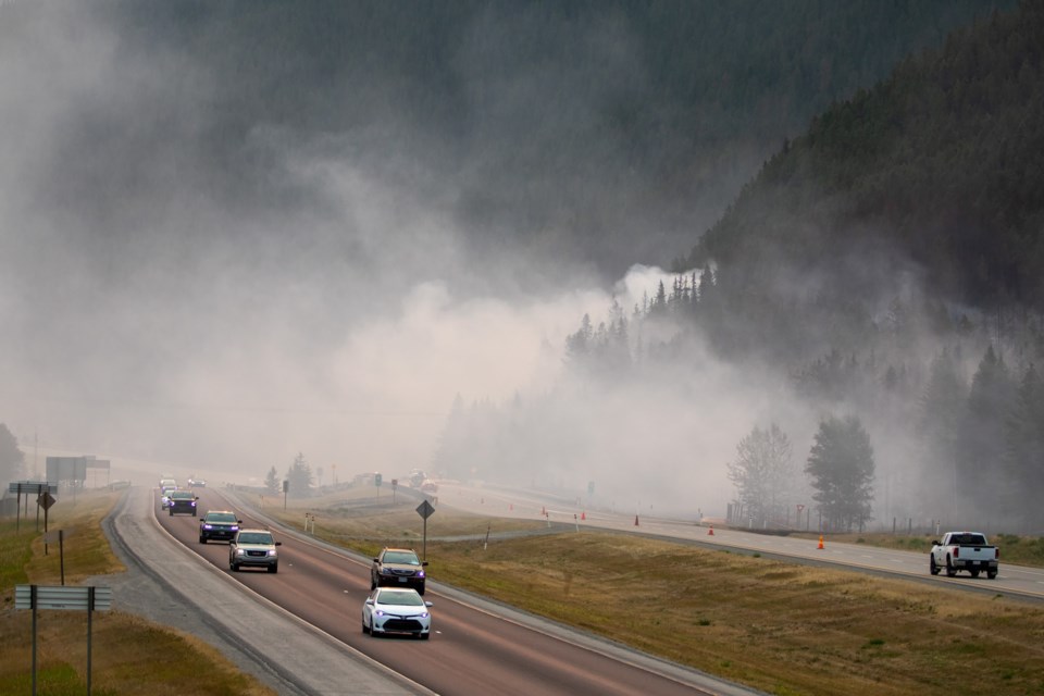
Another key factor in choosing Canmore is the minimal number of ways to get in and out of the community beyond the Trans-Canada Highway in the event of a wildfire evacuation. There’s only Highway 1A and the Smith-Dorrien Highway in Kananaskis Country.
“When we have this number of people trying to evacuate, just on a few number of routes, that presents a key challenge,” said Wong.
One of the end goals of the research will be to determine how infrastructure, such as changes to road networks, multi-modal transportation systems, power or communications, can help make evacuations more efficient and feasible.
“At the same time understanding that we need to ensure that our other goals in infrastructure are maintained, so design, sustainability, safety, efficiency are also being met,” said Wong.
“It’s a tricky balance, but I think for us, we're really particularly interested in temporary capacity improvements to our road networks, not necessarily permanent ones.”
Given answers to the survey, Wong said understanding peoples’ behaviour during an evacuation will be helpful moving forward.
“When we get a chance to see what people intend to do and what they want to do, it also gives us a better sense of people’s risk perceptions," he said.
The Town of Canmore has an emergency preparedness plan and uses the Voyent Alert! mass communication service provider to send alerts to residents, businesses and visitors during emergencies like fires or floods.
The municipality will also provide updates on its emergency alert web page, Facebook page and local media. An evacuation alert will tell people to prepare for an evacuation, whereas an evacuation order will tell people to leave immediately.
Caitlin Miller, director of emergency management for the Town of Canmore, said the municipality also regularly reviews and updates its comprehensive internal municipal emergency management plan.
She said every emergency is different, and there are plans and evacuation routes in place which are dependent upon the specific circumstances of the emergency. Sometimes those circumstances change quickly so plans need to change.
“We don't keep our hazard specific plans or our evacuation plans online because they are so hazard and context specific and we don’t want people to assume something that might be written down for one thing, and use it in a different context,” she said.
“For example, a highway closure because of a major motor vehicle collision on the highway has a very different response than evacuating part of town or evacuating one neighbourhood or another.”
Miller said the most important thing for people to do is stay informed by signing up for the Voyent alerts, which can communicate via phone call, text message or the app.
“By signing up to Voyent Alert!, they'll have the most up-to-date information in a critical incident or emergency,” she said.
“Stay informed and then follow instructions and that will be the safest way for you to be able to evacuate. Sometimes the instruction is to shelter in place.”
The Town of Canmore also advises all residents to have an emergency plan and emergency kit, stocked with supplies such as water, food, battery-powered or crank radio and flashlight, and extra batteries.
Store important documents such as passports, birth certificates, marriage certificates, banking information and insurance papers in a safe place, and if you have a vehicle, keep the tank full in case gas stations lose power or close down.
“You need to be prepared to leave your house for at least 72 hours, if not more,” said Miller.
“We're seeing some of these evacuees from Yellowknife are down here for a few weeks, so you have to make sure you’re prepared for a longer stay.”
The Town of Canmore will communicate where the emergency reception centre will be located, but the first recommendation is to go elsewhere to the homes of friends or family if that is an option.
“That’s the best case scenario if you’re able to go somewhere else safe,” she said.
Miller said the importance of following instructions from government officials cannot be overstated.
“In these cases, we can see the bigger picture, we have more information, we get the context of the hazard, and we're working tirelessly in an emergency to make sure that everybody's safe,” she said.
Canmore residents are encouraged to take part in the survey and can go to https://bit.ly/canada_evac_survey.


