
BANFF – Banff has experienced the warmest May on record and June is shaping up to be just as hot.
Sara Hoffman, a meteorologist with Environment and Climate Change Canada, said Banff was one of nine Alberta communities that recorded the hottest temperatures on record for the month of May.
“May 2023 has been recorded as the hottest May on record in Banff,” she said, noting Banff’s records date back to 1891.
“In Banff, we have 132 years of data so 131 Mays before this were cooler than this May. This is a significant statistic for sure.”
The average temperature in Banff in May, according to long-term statistics, is 8.1 Celsius, which incorporates overnight lows and daytime highs.
“This year in May, we recorded an average temperature of 12 C so it was almost 4 C above that normal,” said Hoffman, noting the hottest day last month was May 15 when the mercury soared to 27.4 C.
According to Environment Canada, Edmonton – which has 142 years of weather data – also experienced the hottest ever May, as did Red Deer, Fort Chipewyan, Fort McMurray, Grand Prairie, High Level, Fort Vermilion and Lloydminster.
Calgary recorded its second warmest May on record, but was very close to breaking the record.
“They had an average temperature of 14.3 C this May, and the hottest ever recorded was 14.5 in 1897 … just 0.2 C away from tying their hottest on record,” said Hoffman.
June is also shaping up to be hot.
Hoffman said the first six days of June were all above normal temperatures for this time of year.
“Normal for this time of year for the Banff area is a daytime high of 18 C, and five of the past six days were hotter than that,” she said.
“On June 4, we actually hit 27 C in Banff, so we were almost 10 C above the normal on the 4th.”
John Pomeroy, director of the University of Saskatchewan’s Centre for Hydrology in Canmore and the Canada Research Chair in Water Resources and Climate Change, said it’s like mid-July in the Rockies.
He said the Canadian Rockies Hydrological Observatory has about 35 stations from Kananaskis Country through Banff National Park to the Athabasca Glacier in Jasper National Park.
“The snow was gone at all of them, and has been gone for weeks,” said Pomeroy, who has been measuring snow depth at these sites since 2004 and has been in the region for 44 years.
“It was the fastest snow melt I've ever seen … I’ve never seen anything like this.”
The early snow melt was a combination of a low snowpack over winter and heat in May.
“It was warm up at high elevations and stayed warm at night, so it just melted and melted and melted,” said Pomeroy.
During a visit to the monitoring station on the Athabasca Glacier in the last week of May, Pomeroy made a sobering discovery – winter melting of the ice.
“It was May 30 and I couldn’t believe my eyes. There’s no snow below the icefall,” he said.
Pomeroy had last been at the Athabasca station on Sept. 23 last year, which was also unseasonably warm at about 15 C on the ice.
There, the team drilled down a pole about five or six metres into the ice to attach a snow depth gauge, and as the ice melts, the pole is exposed. Black electrical tape is wrapped around the pole where it comes out of the glacier ice.
"I came back last week and that electrical tape is 1.7 metres up in the air, so we had 1.7 metres of glacier melt over what would be considered a winter period," said Pomeroy.
"About 20 cms of that occurred in September and October, which itself is strange, but then it started melting in April this year, and into May."
Pomeroy said he has never before seen winter melting on the glacier.
"It's impossible to keep the glacier going with six months of winter. We're seeing winter melting on the glaciers and they are probably going to melt out faster than we thought," he said.
"It's not often I would use the word tipping point, but I would use it here when we see something that is exceptional showing up.”
While he can't say when, Pomeroy predicts the glaciers in the Rockies will recede faster than previous predictions.
“I sort of thought Peyto Glacier would be done this decade, and I thought the Athabasca would hang on into late in the century,” he said. “Now I’m thinking they won’t make it that long.”
Meanwhile, Pomeroy said flows in the Bow River, which don’t typically peak until well into June, already peaked in the middle of May, running at about 140 cubic metres per second and now down to about 72 cubic metres per second.
“The flows in the Bow River have dropped in half in the last 10 days, and they're on the way down,” he said.
“They’re already in the lowest quarter of measurements for this time of year, when normally they'd still be rising. Instead, they’re plummeting," he added.
“The snow is exhausted and they're relying on what's left for glacial melt.”
The flow rates compare to the more than 400 cubic metres per second during the height of the catastrophic 2013 floods.
Although it peaked in the middle of May this year, Pomeroy said that doesn’t mean the Bow River can't rise again.
“It would take an extremely heavy rainfall, but the thing is that the Bow River and Elbow River are very flashy,” he said.
“If the rainfall causes them to rise, sometimes they rise too quickly.”
Joel Hagen, a long-term resident of Lake Louise and interpretive guide with his business Great Divide Nature Interpretation, said the rise in temperatures so early in the year is extremely alarming.
“I know a lot of people have been enjoying the weather this last month, but personally, I found it very disturbing to see a month of temperatures sitting 10 degrees or more above long-term averages,” he said.
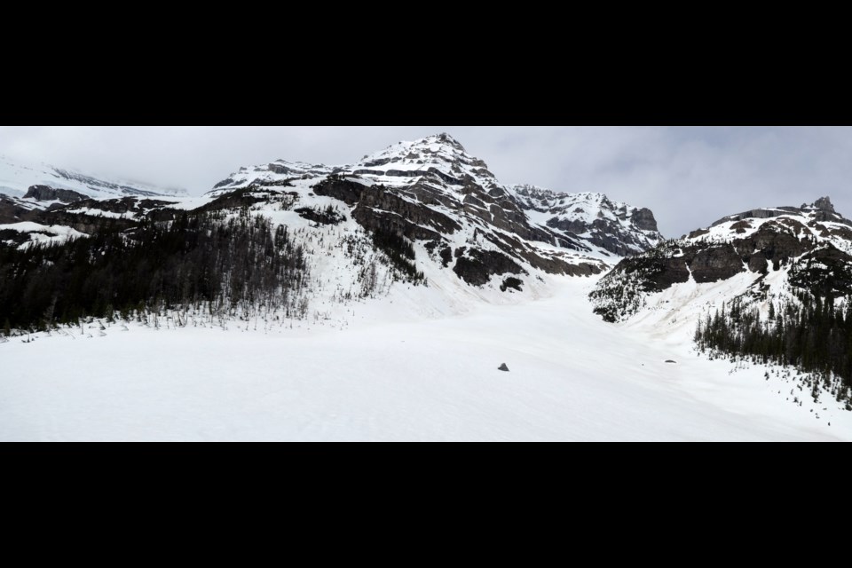
“Here in Lake Louise, there is very little snow persisting, even at high elevations, and I can only imagine that this will have a big impact this summer on rivers, glaciers, and, possibly, wildfires.”
Hagen took two photos at the same place on the Plain of Six Glaciers trail a year apart – one on June 4, 2022, and the other on June 2 this year.
“I recognize that last year the spring snowpack really hung on longer than usual, but in 30 years of living here, the Plain of Six Glaciers trail has almost always still been snowbound in its upper reaches in early June,” he said.
Not only was May hot, it was also dry, which does not bode well for the fire season ahead.
Banff National Park hit extreme fire danger earlier this week, while Lake Louise, Yoho and Kootenay sit at very high.
Hoffman said it was the 38th driest spring on record going back through 132 years of Banff data.
She said Environment Canada’s Banff site recorded 31.3 millimetres of rain for the month of May, compared to the normal of 59.6.
“It was about 28 millimetres less, so about half of what Banff typically sees in May,” she said.
According to Environment Canada, Banff has only seen 3.4 mm of rain in the first seven days of June, typically the rainiest month of the year in the Bow Valley and referred to by locals as June Monsoon.
“Our guidance is telling us that it will be a near normal June in terms of precipitation for Banff and Canmore, yet of course, it’s not starting out that way,” said Hoffman.
“By the end of the week, we have three days in a row where we’re expecting showers and thunderstorms over the area, so hopefully that makes up for the dry start to the month.”


