
The Pocaterra trail is one of the most popular routes in Kananaskis Country. From it, hikers can access the Whiskeyjack trails, the fire lookout and beyond into the dense backcountry. Like many of the hikes in the Highwood region, it’s at high elevation and usually quite arid.
So when Kananaskis trail crews found a cutthroat trout flopping in a puddle in the middle of the popular trail, it was indicative of the amount of sheer destruction the flood of the century had wreaked upon the 4,211 square kilometres of wild land.
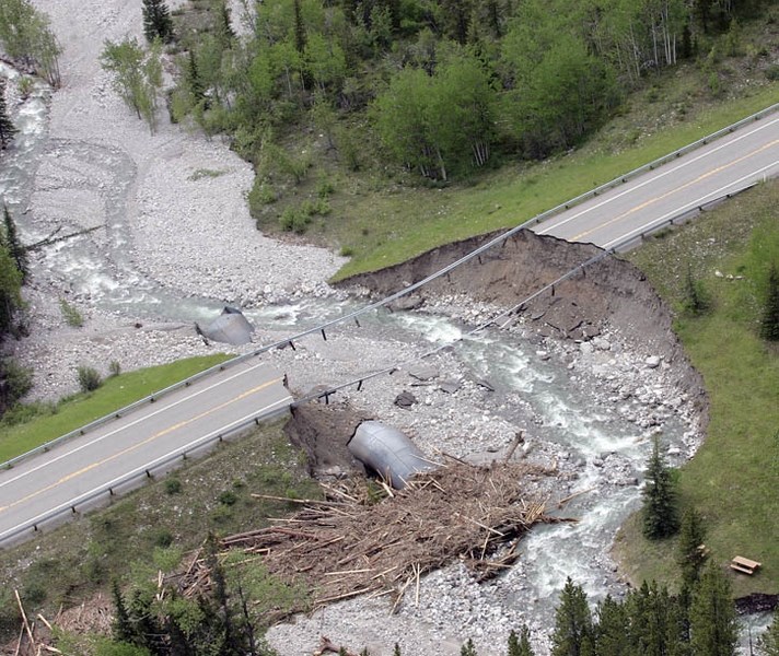
Three hundred and twenty millimetres of rain fell in a span of 30 hours over Kananaskis Country, carving holes in Highway 40, washing out 400-metre long bridges and crushing culverts across the landscape.
Every backcountry trail sustained some damage – the Chester and Sawmill trailheads are under huge piles of debris, Mount Kidd R.V. Trailer Park is still closed due to sewage issues, the Beckie Scott High Performance Training Centre on the Haig Glacier is closed until August and the Kananaskis Golf and Country Club is decimated.
Kananaskis Area Manager Dave Hanna and Michael Roycroft surveyed the damage by helicopter Thursday (June 27), and witnessed bridges littering river banks, picnic tables gone missing and creeks re-routed through buildings.
“It’s heartbreaking. These are places people love to go and recreate. It’s going to take some time to get open and available to the public,” Roycroft said.
A week after the deluge, Alberta Parks is still making a laundry list of repairs. Much of the initial four days of work consisted of evacuation: 1,200 people in total, 400 by helicopter.
Now, the hard cleanup work begins and officials aren’t yet prepared to put a dollar figure on the work. Fifty per cent of parkland is still under ministerial closure, but more openings are expected this week. Spray Lakes Road should be open for the weekend, and Grassi Lakes trail is also open to the public. Rafting has resumed on the Kananaskis River and the Widowmaker and Canoe Meadows kayak areas are open again.
Over the July 1 long weekend, conservation officers said restrictions were not respected on many trails, especially Heart Creek and Heart Mountain.
“Trying to understand the scale and the scope of the damage and get a good sense of what’s out there is the next challenge,” Roycroft said.
The sheer number of damaged roads and trails is slowing recovery efforts. Highway crews have been working steadily for days, yet there is still no timeline for all repair efforts. Alberta Transportation and Alberta Parks are working together to get infrastructure open as fast as possible.
“Alberta Parks staff are doing assessments to make sure key infrastructure is secure.
“We’re trying to do the best we can, but many transport and connectivity routes are closed,” Roycroft said. “One of the biggest issues is simply access. There are a number of landslides across highway 40, 66 and so on. It will take some time to get things open.”
Highway 40 is now open from the Trans-Canada Highway to Wedge Pond and Kananaskis Village is now fully operational. Several picnic and frontcountry campgrounds are slowly opening, but many hiking trails are forever changed.
“The experience will be a little different. Those favourite hiking trails you used to use, in some areas, will have to be re-routed. In some areas, they’ll have to be changed,” Roycroft said.
District Conservation Officer Glenn Naylor said anyone planning to recreate in Kananaskis should call ahead first to the flood line: 403-678-0760. He said the most popular hiking trails will get priority, but trail users will have to be patient.
The rain didn’t significantly affect wildlife, according to Hanna, although some favourite dining spots are under water. The meadows in front of the Peter Lougheed Provincial Park day use area used to be prime grizzly bear habitat. Now, the meadow is completely submerged under several feet of water.
“Some of their traditional areas are under water, so the bears have been displaced,” Hanna said.
Beneath the helicopter, grizzly bears still grazed in the meadows near Highwood Pass, and moose still trounce through wetlands.


